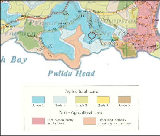
Composite map showing land grades in the Bishopston area
Note: darker blue land is Grade 1 - the best and most versatile

Unlike some parts of England, Wales has never been surveyed comprehensively for ALC Grade at better than 1:250,000 scale - and the ARAD ALC Survey database at Aberystwyth confirms that the individual fields at this site have never had a detailed survey on an ad hoc basis.
However, the above map shows that the land at the site in question is certainly Grade 1 (the best and most versatile land). It was produced using a street level map of the area, with the site circled, superimposed on an extract from the official 1:250,000 ALC map for Wales. As is clearly evident, the site is unequivocally Grade 1 according to the ALC map, as is all agricultural land in the immediate surrounding area. Other adjacent land is Grade 2 and, further from the site, Grade 3. There is no Grade 4 or 5 land present in the locality.
It is well worth noting that Grade 1 land accounts for only a tiny percentage (less than one quarter of one percent - 0.22% - source; Welsh Assembly Government) of all agricultural land in Wales, and so is indeed a very scarce resource whose conservation must surely be a priority. Grade 2 land accounts only for a further 2.24% (source; Welsh Assembly Government). Even in West Glamorgan (as was) - a relatively fertile area of Wales - land at Grades 1 to 3a inclusive accounts only for 15% of all agricultural land (source: Planning Policy A1).
The following points are also worthy of note:
Source: MAFF 1966 Agricultural Land Classification for England and Wales, ARAD ALC Survey database - Welsh Assembly Government, ALC Technical document, Defra, © copyright Keep Gower Green